Toronto, Ontario--(Newsfile Corp. - April 2, 2026) - Canuc Resources Corporation (TSXV: CDA) (OTCQB: CNUCD) (WKN: A41V6H) ("Canuc" or the "Company") is pleased to announce that OptiSeis Solutions Ltd. ("OptiSeis") has initiated a Seismic Survey on Canuc's 100% owned East Sudbury Project (ESP) (Figure 1), a property spanning ~ 200 km2 and located some 20 km East of Sudbury Ontario, Canada. The survey is supported by Natural Resources Canada (NRCan) through its Critical Minerals Geoscience and Data Initiative (CMGD) and is targeted at Canuc's McLaren Lake Fault Zone (MLFZ), a known Metasomatic Iron Alkali-Calcic (MIAC) system.
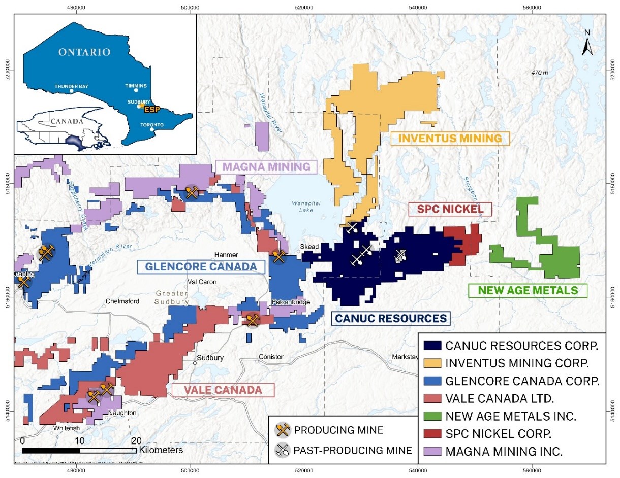
Figure 1. Canuc's East Sudbury Project (ESP) Regional Setting
To view an enhanced version of this graphic, please visit:
https://images.newsfilecorp.com/files/2906/290894_60e312f1444b4bcd_001full.jpg
OptiSeis specializes in high resolution surface and subsurface visualization utilizing 2D, 3D, 4D, and VSP (Vertical Seismic Profile) seismic data. The planned project with Canuc and NRCan will involve acquiring combined high-resolution 2D and VSP seismic data in order to optimize the subsurface imaging of both local and regional discontinuities, such as faults, fractures, and lithological boundaries, at a known Cu-Au mineral deposit near Sudbury. In particular, imaging will focus on the McLaren Lake Fault Zone (MLFZ), which has been shown to host significant Cu-Au mineralization, along with Co, Ni, and PGE, within hydrothermally altered rocks.
"This project aims to image the subsurface structural controls governing the deposit, with a focus on deeper features. OptiSeis has extensive experience working in these complex structural environments and the combination of surface and borehole (VSP) seismic data has the potential to map the true depth and full lateral extent of this mineralization," stated Andrea Crook, P.Geoph, founder and CEO of OptiSeis.
The program will utilize more than 1,300 state-of-the-art autonomous node sensors, representing the latest advances in seismic acquisition technology, along with low-impact Vibroseis methods designed to minimize environmental and surface disturbance. With extensive collaboration between OptiSeis, Canuc, and NRCan the program has been designed with a minimal surface footprint. Field activities have also been carefully planned to minimize impact on local land users and surrounding communities. The survey will be executed by a crew of approximately 15 personnel and is expected to be completed over a period of 7-10 days.
Multiple high-resolution 2D seismic lines will be acquired along roads and access within the study area with a focus on ensuring proper azimuthal and offset coverage around the MLFZ. In total, 13.5 km of seismic lines will be acquired with seismic receivers from all lines recording signals from all Vibroseis sources, resulting in pseudo-3D subsurface coverage at some locations. This configuration enables the generation of multiple 2D reflectivity sections in addition to conventional 2D line transects and was generated utilizing OptiSeis' proprietary osDesign™ software platform. Furthermore, portions of the subsurface targets can be processed using VSP and 3D seismic imaging algorithms to improve understanding of the structural complexity of the mineralized fault zones.
Application of Artificial Intelligence (AI) and Machine Learning to Integrated Data Sets
Results from this study will be integrated into combined analysis that examines not only the seismic data but also results from the recently acquired Gravity Gradiometric Survey completed by Bell Geospace Ltd. (Bell Geo) along with other geological data from across the property.
Applying artificial intelligence (AI) to the subsurface data enables an entire data set to be analyzed holistically. This integrated approach to planning, design and interpretation can improve data quality and provide insights that might otherwise be overlooked, ultimately improving the accuracy and confidence planning for subsurface operations. Improved imaging of these structures is also expected to enhance understanding of fluid migration pathways associated with critical mineral deposits in Canada.
"Canuc is moving quickly to collate data in the search for large-scale source deposits on the company's ESP claim holdings," stated Chris Berlet President and CEO of Canuc Resources Corp.
"We are delighted to have industry leader Optiseis Solutions Ltd. conducting a Seismic Survey with the endorsement of Natural Resources Canada, and to be able to combine results of this work with a Gravity Survey being undertaken concurrently by Bell Geospace Ltd."
"These surveys, and their interpretation, will lead Canuc into an exciting new exploration phase on the company's 100% owned ESP claim group located just east of Sudbury Ontario, one of the world's most successful and well developed mining and exploration jurisdictions. We hope to be targeting the prospective large-scale IOCG type copper-gold-cobalt source deposits that may be identified by this work, for drill testing as early as possible after mid-year 2026."
Canuc's updated website and PowerPoint can be found at: www.canucresources.ca
The technical information in this release has been reviewed and approved by Seymour Sears, B.A., B.Sc., P.Geo, a non-independent qualified person as defined by NI 43-101, who is currently managing exploration activity on the ESP Project.
About Canuc Resources Corporation
Canuc Resources Corporation is a junior resource company developing its 100% interest in the East Sudbury Project ("ESP") which spans 19,710 hectares and is centered approximately 20 kilometers northeast of the Prolific Sudbury Mining Camp and near to the extensive infrastructure of the adjacent Sudbury Mining District. ESP encompasses several centers of critical and precious metal mineralization interpreted to be related to a mineral system that can form IOCG and affiliated critical and precious mineral deposits. Included within the Project is the historical Scadding Gold Mine and associated Scadding Gold Tailings Project.
Canuc also holds a 100% interest in the San Javier Silver-Gold Project located in Sonora State, Mexico. The San Javier Silver-Gold Project spans 28 claims covering 1,052 hectares and evidences extensive silver, gold and copper mineralization interpreted to be related to a mineral system that can form silver-dominant IOCG and affiliated deposits.
Canuc generates cash flow from natural gas production at its MidTex Energy Project located in Central West Texas, USA where Canuc has an interest in eight (8) producing natural gas wells and has rights for further in field developments. The Company also receives a 4% Net Smelter Royalty from gold production at the Scadding Gold Tailings Project located on Mining Claim LEA 107735 within the ESP property group.
For further information please refer to the Company website: www.canucresources.ca
Christopher J. Berlet B.A.Sc.(Mining), CFA, CEO & Director of Canuc, is responsible for the content of this press release.
For further information please contact:
Canuc Resources Corporation
(416) 525 - 6869
cberlet@canucresources.ca
For information on Bell Geospace and FTG surveys please contact:
bmain@bellgeo.com
Forward-Looking Information
This news release contains forward-looking information. All information, other than information of historical fact, constitute "forward-looking statements" and includes any information that addresses activities, events or developments that the Corporation believes, expects or anticipates will or may occur in the future including the Corporation's strategy, plans or future financial or operating performance.
When used in this news release, the words "estimate", "project", "anticipate", "expect", "intend", "believe", "hope", "may" and similar expressions, as well as "will", "shall" and other indications of future tense, are intended to identify forward-looking information. The forward-looking information is based on current expectations and applies only as of the date on which they were made. The factors that could cause actual results to differ materially from those indicated in such forward-looking information include, but are not limited to, the ability of the Corporation to fund the exploration expenditures required under the Agreement. Other factors such as uncertainties regarding government regulations could also affect the results. Other risks may be set out in the Corporation's annual financial statements, MD&A and other publicly filed documents.
The Corporation cautions that there can be no assurance that forward-looking information will prove to be accurate, as actual results and future events could differ materially from those anticipated in such information. Accordingly, investors should not place undue reliance on forward-looking information. Except as required by law, the Corporation does not assume any obligation to release publicly any revisions to forward-looking information contained in this press release to reflect events or circumstances after the date hereof.
Neither the TSXV nor its Regulation Services Provider (as that term is defined in the policies of the TSXV) accepts responsibility for the adequacy or accuracy of this news release.
![]()
To view the source version of this press release, please visit https://www.newsfilecorp.com/release/290894
COMTEX_476431172/2523/2026-04-02T09:00:57