OAKVILLE, Ontario, Feb. 25, 2026 (GLOBE NEWSWIRE) — La Nina and the polar vortex teamed up to deliver a fickle but high impact winter to most of Canada. Will this turbulent weather continue through the upcoming spring season?
To answer this question, The Weather Network has issued their spring forecast for the months of March, April and May.
“Spring isn't just a season in Canada–it's the scenic route from winter to summer, and this year, it looks like we are in for a bit of a trek,” said Doug Gillham, senior meteorologist with The Weather Network. “Spring rarely takes us on a straight path from winter to summer and this year will be a prime example. Our journey to summer will include many detours and even some backtracking into winter. But rest assured that we will get there! For parts of Canada the long winding road could end rather suddenly with an abrupt transition into summer.”
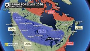
Most of Canada will see near normal or colder than normal temperatures, especially during March and April. However, May is still a wild card with the potential for a quick transition to early summer-like conditions for at least part of the country.
Rain (and snow) are typically plentiful during spring and we expect that most of Canada will have near normal or above normal precipitation totals through at least April. However, parts of western Canada could trend much drier as we head into early summer.
Below is a more detailed look at the conditions that we expect across Canada this spring:
Ontario & Quebec – Winter started early and it does not appear to be in a hurry to leave as a sluggish start to spring is expected. This should extend the ski season but delay the start of the growing season. There will be stretches with above seasonal temperatures and even tastes of early summer weather, but the warm weather will lack commitment and be offset by periods of colder weather. Above normal precipitation totals are expected, especially through April, and this could impact preparations for the start of the planting season.
British Columbia – Spring-like weather began exceptionally early, but that proved to be a false start to spring as more typical late winter weather arrived for the second half of February. Temperatures are expected to be near seasonal or cooler than seasonal during March and most of April. Above normal precipitation is also expected through April. This will allow for excellent spring ski conditions across the interior and bring the potential for a stronger ending to a disappointing season for the south coast region. However, May will bring the potential for an abrupt transition to early summer-like weather.
The Prairies – This past winter was interrupted by an extended thaw, including record breaking warm temperatures. However, that has proven to be a false start to spring as winter weather has returned with a vengeance. Spring will continue to feature changeable temperatures, but colder than normal conditions are expected to dominate during March and well into April. Chilly temperatures and above normal precipitation (including more snow) could impact preparations for spring planting, but we expect spring will finish strong with a much warmer and drier pattern forecast to arrive during May, especially for Alberta.
Atlantic Canada – A typical spring is expected across the region with changeable temperatures and an active storm track which should deliver near normal precipitation totals across the region. This will include the usual risk for significant late winter-like weather, but periods of warm weather will offset the periods of cold weather and become more dominant as the season progresses.
Northern Canada – Above normal temperatures are expected to continue to dominate across Nunavut. Near normal temperatures are expected elsewhere except for southeastern parts of the Yukon territory and the southwestern corner of the NWT where temperatures could tip to the cold side of seasonal. Near normal precipitation is expected across the region, but parts of the region could trend drier as we head into the beginning of summer.
| The Weather Network: Spring 2026 Forecast | ||
| Region | Temperature Outlook | Precipitation Outlook |
| British Columbia | Near normal; Below normal north | Near normal; Above normal south |
| Alberta | Below normal; Near normal southwest | Above normal south; Near normal north |
| Saskatchewan | Below normal | Above normal south and central; Near normal north |
| Manitoba | Below normal; Near normal far north | Above normal; Near normal southeast and north |
| Ontario | Below normal; Near normal far south | Above normal south and east; Near normal northwest |
| Quebec | Near normal; Below normal west; Above normal north | Above normal south and west; Near normal east and north |
| The Maritimes and Newfoundland | Near normal; Above normal Labrador | Near normal |
| Yukon, Northwest Territories, Nunavut | Above normal Nunavut; Below normal southeast Yukon and southwest NWT; Near normal elsewhere | Near normal |
Canadians can check daily forecasts by visiting www.theweathernetwork.com or by downloading The Weather Network App available on iOS and Android, and creating an account for personalized and up-to-the minute forecasts.
Complete spring forecast details, including regional breakdowns, maps and charts are available on our seasonal page at theweathernetwork.com/spring.
Interview opportunities: The Weather Network meteorologists are available for interviews between February 25-27 to provide additional details and localized insights on what Canadians can expect for the spring season.
To arrange an interview with a meteorologist, please contact:
Madelaine Lapointe
mediainquiry@pelmorex.com
About Pelmorex
Pelmorex is the company behind the well-known trusted weather brands, The Weather Network, MeteoMedia, Eltiempo, Otempo and Clima. Its mission is to provide fast, accurate weather forecasts, personalized insights and critical weather alerts, empowering people, communities and businesses worldwide to make informed decisions amidst the changing weather. This core intelligence is extended through Pelmorex Weather Source, its enterprise division, which helps companies turn weather uncertainties into strategic advantages. Pelmorex is also a key public safety partner and operates Canada's National Alert Aggregation and Dissemination System, part of the Alert Ready emergency alert system.
To learn more, visit Pelmorex.com and follow us on LinkedIn.
A photo accompanying this announcement is available at https://www.globenewswire.com/NewsRoom/AttachmentNg/c01f50bd-5fe6-45b7-b6e5-86cd88fa847c

![]()
Spring forecast – Temperature