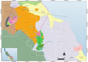
ARAWA, Papua New Guinea, Dec. 22, 2025 (GLOBE NEWSWIRE) — Island Passage Exploration Limited (IPX or the “Company”) has made extensive progress during the last three quarters in its copper-gold exploration program at the EL02 exploration license in the Autonomous Region of Bougainville (AROB), Papua New Guinea (Figure 1).
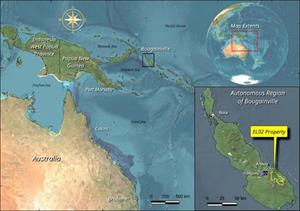
 Figure 1 – Location Map of Bougainville Island and EL02 License
Fielding two geological teams in alternating field rotations on the EL02 project since March of this year, the pace of work has increased markedly. In addition to the large-scale stream sediment anomalies and high-grade veins already reported during 2024 and early this year, the IPX team has now identified a significant porphyry copper-gold target hosted in monzonite and porphyritic diorite at the Bara-Tangka target. The team noted widespread enrichment of copper, gold, and molybdenum in rock samples over several square kilometres, where a deeply-rooted magnetic intrusive has been interpreted from airborne geophysics. The follow-up led to detailed sampling, mapping, and a large-scale soil grid. The results have exceeded the Company's expectations as recent channel samples have returned copper, gold, silver, and molybdenum grades of potentially economic grade and width. There is also a huge soil anomaly developing, which is currently undergoing detailed fill-in sampling. Selected results and highlights are summarized below:
- Key channel sample results at Bara-Tangka Porphyry Target:
- 47.0m at 0.56% Cu, 0.49 g/t Au, 5.9 g/t Ag, and 0.018% Mo, including
- 6.0m at 0.67% Cu, 0.95 g/t Au, 24.6 g/t Ag, and 0.13% Mo; and
- 6.0m at 0.73% Cu, 1.13 g/t Au, 5.51 g/t Ag, and 0.007% Mo;
- 20.0m at 0.50% Cu, and 0.14 g/t Au;
- 27.0m at 0.22% Cu, and 0.12 g/t Au;
- 6.0m at 6.36 g/t Au, 2.48 g/t Ag, and 0.014% Mo;
- 6.0m at 0.38% Cu, and 0.10 g/t Au.
- 47.0m at 0.56% Cu, 0.49 g/t Au, 5.9 g/t Ag, and 0.018% Mo, including
- Key channel samples at Marai Target:
- 3.8m at 3.57% Cu, 4.40g/t Au, and 19.67 g/t Ag.
- Key channel samples at the Isina Target:
- 3.0m at 6.7 g/t Au, and 0.11% Cu;
- 3.0m at 11.3 g/t Au, and 3.45 g/t Ag;
- 6.0m at 1.2% Cu;
- 7.0m at 0.53% Cu, and 0.19 g/t Au;
- 2.0m at 27.2 g/t Au and 4.5 g/t Ag.
- Property-wide rock sampling (1,380 samples) returns extraordinarily high gold and copper, likely indicating a rich endowment of gold and copper in the source magmas:
- Mean Au = 2.04 g/t Median Au = 0.07 g/t Maximum Au = 454 g/t
- Mean Cu = 0.278% Median Cu = 329 ppm Maximum Cu = 13.83%
- More than 1,200 soil samples collected so far. Newly completed 200 x 200m soil grid at Bara – Tangka target has revealed strong Cu and Au anomalies covering more than 4km2, including a maximum Cu value of 0.297%
- Geologists have completed extensive geologic mapping that has documented multi-phase intrusive rocks, which exhibit large-scale chlorite-epidote-albite-calcite-clay alteration, as well as more intensive local white mica and biotite-K-feldspar alteration.
- The team is developing a structural model wherein arc-parallel fabric intersections with orthogonal and certain oblique structures are highly correlative with both precious metal and porphyry copper – style mineralization.
Patrick Highsmith, IPX President and Co-Founder, commented on the latest results, “Our team has rapidly progressed the EL02 project from boot leather driven reconnaissance to drill target development. We have been reporting high-grade vein samples for over 12 months, and now we have progressed to reporting lengthy channel samples of continuously mineralized porphyry-style alteration. This evolution is significant because we can now see and understand the presence of several different magmatic hydrothermal systems on the license. While the level of exposure and chemistry of these systems may be different, the spectacular enrichment in copper, gold, and molybdenum over such a large area as we see at Bara – Tangka sends a clear signal – this is what a discovery looks like. Our excitement is, of course, enhanced since the target lies less than 13km from the giant Panguna deposit.”
IPX Chairman, CEO, and Co-Founder, Donald McInnes, added, “The numbers from EL02 continue to impress us, but the large footprint of the new Bara-Tangka target has really increased our momentum. We are now developing targets and planning for our first drilling campaign, which could occur towards the end of Q1or early Q2 of 2026. Our partners and stakeholders recognize the significance of this accomplishment, as there has been no exploration drilling on Bougainville in over 40 years.”
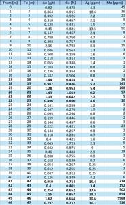
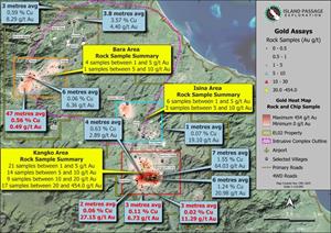
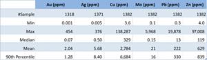
After completing a comprehensive stream sediment survey across the 250 km2 license, the IPX team followed up on approximately a dozen gold (Au) and copper (Cu) anomalies, often with supporting anomalies in silver (Ag), molybdenum (Mo), and other elements. Prospecting and preliminary mapping in the vicinities of the stream sediment anomalies quickly identified high Au, Ag, Cu, and Mo in rock and channel samples, often associated with alluvial and small-scale mining. The Company has noted at various times that background levels of gold and copper, in particular, are remarkable. Even after 1,300 rock samples have been analyzed, the mean values of gold and copper in the database are 2.04 g/t and 0.278%, respectively (See Table A1). Outstanding polymetallic geochemical anomalies focused the team's work on four seemingly discrete magmatic-hydrothermal systems at Isina, Bara-Tangka, Marai, and Enara (Figures 2 and 3).
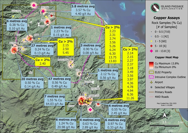
Figure 2 – Copper in Rock Samples and Major Targets Across EL02
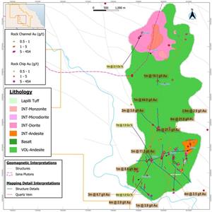
Detailed Discussion of Isina Vein Corridor Target
As previously reported by IPX on February 14, 2025, the greatest concentration of high-grade Au and Cu encountered on the license occurred in the polymetallic vein systems discovered at the Isina Target (SE portion of license). Bonanza grade rock chips (>20 g/t Au, >100 g/t Ag, and >2% Cu) occur at key structural intersections in these intermediate sulfidation vein systems. The IPX team has continued exploration work up and down the Isina vein corridor, which has now been documented to host mineralized veins over at least 4.5km of strike. In addition to geologic mapping, prospecting, and filling in stream sediment samples in the area, IPX field teams have also begun collecting soil samples in the southern part of the trend. Figure 4 is a preliminary geologic map of the Isina Vein Corridor that also shows a number of channel sample results for gold and copper.
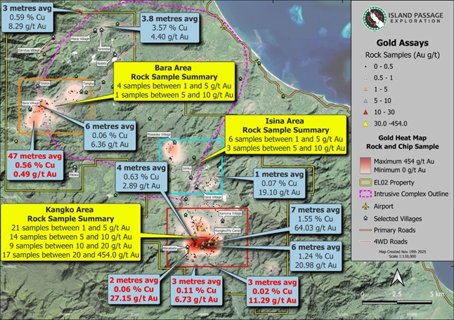
Figure 3 – Gold in Rock Samples and Major Targets Across EL02
These intermediate sulfidation vein systems occur in at least 5 different sets of multiple veins (having vein densities of 1 to 10 veins per metre) trending broadly northerly and dipping steeply. Where these northerly striking structures intersect with major orthogonal structures, or other crossing features, Company geologists observe greater thickness and often higher grade in the veins. These structural intersections result in significant widths of vein breccias and wallrock silicification with accompanying mineralization. The high-grade mineralized veins and altered wall rocks are typically 1 to 3m thick (2.0m at 27.2 g/t, 3.0m at 11.29 g/t, and 3.0m at 6.73 g/t Au), but geologists have measured mineralized true widths of up to 8.3 metres when encompassing lower grade mineralization in the shoulders of the veins (8.3m at 0.3 g/t and 0.17% Cu).
The Company has commissioned initial petrographic rock descriptions, including scanning electron microscopic (SEM) analysis. These veins and breccias crosscut (dominantly) volcanic rocks of andesitic composition and lesser intrusive rocks (syenogranite, rhyodacite, and diorite). Weak to moderate alteration in the area is nearly ubiquitous – dominated by chlorite, epidote, albite, calcite, quartz, and illite, but including adularia, kaolinite, and actinolite. The veins and vein breccias are typically composed of quartz-sulfide+magnetite or quartz-adularia-sulfide-hematite. The dominant sulfides present in the veins and disseminated alongside the veins are pyrite, chalcopyrite, sphalerite, cubanite, bornite, and galena, sometimes overprinted by secondary covellite, digenite, chalcocite, and other phases. Electrum is often reported by microscope and more rarely in hand sample. Figures A1 – A4 in the appendix to this news release display typical small mines exposing the veins and selected photomicrographs from highly mineralized veins.
Since the vein targets in the Isina corridor tend to be relatively narrow and high grade, the first soil grid is being designed with sample stations on 25-metre spacing along lines that are spaced 100-metres apart. Early results from test sampling indicate that the veins are yielding multi-element anomalies over several stations using these spacings.
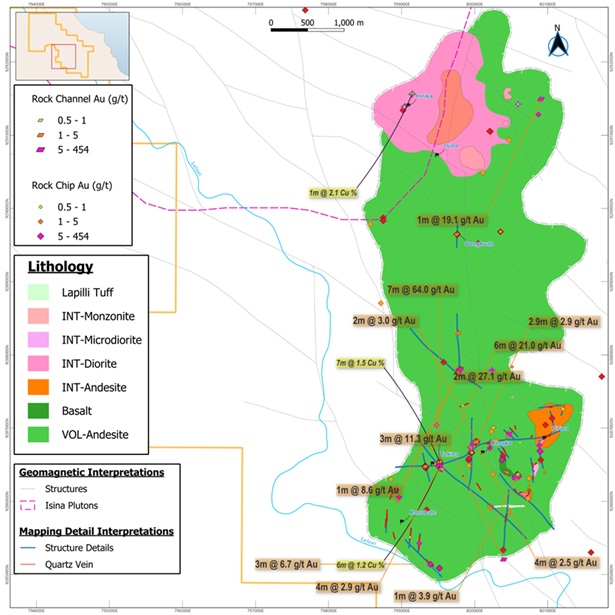
Figure 4 – Preliminary Geologic Map of Isina Vein Target with Selected Channel Samples
During August, the teams pushed farther east and southeast where they encountered previously unseen vein occurrences. The new veins discovered in the southeast part of the license strike dominantly in a northeasterly direction, and they range from centimetre to 0.5-metre in width. The hosting structures often reflect vein breccias and several metres of silica, clay (white mica), chlorite, hematite, manganese alteration crosscutting the volcanic host rocks. The veins in this area exhibit banding and bladed textures (quartz replacing calcite) that may be indicative of a shallower environment than many other showings on the property. Assay and geochemical results are still pending from this recent campaign, but geologists documented secondary copper oxides at numerous prospects.
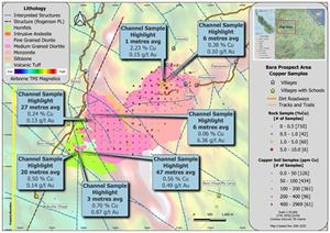
Detailed Discussion of Bara – Tangka Porphyry Copper Target
Since the Company's last technical news release in Q1 of this year, IPX geologists have invested considerable time following up on high-grade copper occurrences within the Isina Pluton, which is comprised of monzonitic to granitic composition. This intrusive complex was partially mapped by the PNG Geological Survey (Rogerson et al, 1989) as the Isinai Monzonite and documented as the largest known intrusive complex on Bougainville Island (Figure A5 in the appendix to this news release). The intrusive complex also hosts several magnetic anomalies evidenced by the 1986 airborne geophysical survey flown by the German government for the Papua New Guinea government. IPX has reprocessed and modeled the geophysical data and identified several discrete magnetic features near the margin of the intrusive complex, some of which appear to be deeply rooted and to occupy key structural settings.
IPX reported rock chip sampling results in February 2025 of 13.75% Cu, 2.65% Cu, and 2.15% from the Marai, Enara, and Tangka targets, respectively. Follow-up exploration has significantly expanded the footprint of high-grade Cu, Au, and Mo in the Marai and Bara-Tangka areas. As the IPX teams moved into the Bara-Tangka area to investigate the structurally controlled veins observed in the diorite, geologists noted widespread quartz-illite-chalcopyrite-molybdenite veins cutting chlorite-epidote-biotite-(magnetite) altered diorite. The mineralized veins are often spatially associated with faults. The individual veins are millimetre to centimetre scale in width, but they occur in sets, typically oriented NW. However, there are orthogonal vein sets, and the intersection of these structures seems to have controlled at least one structure containing mineralization over 6 metres, 6.0m at 0.4% Cu. In addition to these arc-parallel and arc-normal orientations, geologists have been mapping and sampling veins oriented along E-W and N-S striking fabrics.
The IPX team's reconnaissance of the area turned up numerous mineralized showings. In over 300 rock samples collected in the target area so far, the average values are 0.3% Cu, 0.35 g/t Au, and 3.9 g/t Ag. Molybdenum is also highly enriched over a large area, averaging 64 ppm and having two samples with more than 0.3% Mo (maximum of 0.6% Mo). Almost 50% of the rock samples collected in the Bara-Tangka area contain more than 0.1% Cu and/or 0.1 g/t Au. While low-grade gold is widespread in the target area, there is one example of higher-grade gold associated with multiple directions of veining cutting chlorite-epidote altered diorite. Channel sampling on this feature averaged 6.36 g/t Au over 6.0 metres, including 1.0m of 18 g/t Au. The chemistry and textures of this occurrence suggest an epithermal affiliation.
Low to moderate grades of copper, gold, and molybdenum are very widespread over an area covering more than 8 km2. Coincident with prospecting and sampling campaigns, the senior geologists from the IPX team conducted geologic mapping at each prospect, eventually building a preliminary geologic map of the target corridor. See Figure 5.
There are several important features of the geology at this scale. This part of the intrusive complex is comprised of multiple phases, ranging from (likely) older monzonite to younger porphyritic diorite. The contact of the intrusive complex with the sediments on the west and southwest is strongly hornfels-altered. Various structural orientations are also evident in the mapping, as lithologic contacts and certain mineral showings appear to align with, or be controlled by, faults – both those interpreted from airborne magnetics and confirmed by ground measurements.
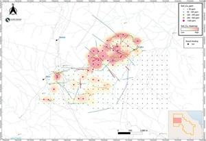
The team initiated ridge-and-spur soil sampling in areas of sparse outcrop adjacent to some of the mineralized vein areas. However, realizing the scale of the Cu-Mo-Au footprint in rocks, the team accelerated the soil sampling with a widely spaced grid on 200m spacings, initially targeting ~8km2 and now expanded to more than 12km2. The wide spacing allows rapid coverage of the target area, and the team will follow up in anomalous areas and fill in with higher resolution sampling. The initial copper results of the soil grid are shown in Figure 6.
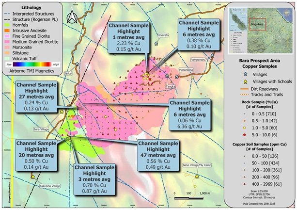
Figure 5 – Preliminary Geologic Map of Bara – Tangka Target with Selected Channel Samples
The large copper anomaly began to appear in the first ridge-and-spur sampling in the northeast of the map area, and the grid now reflects a large cohesive copper anomaly spanning almost 2km x 1km in the northern part of the grid. In addition, there are numerous other multi-point anomalies that will require follow-up work. The local maximum value for copper in these soils is 2,969 ppm (0.297% Cu). The copper is corroborated by gold, silver, and subtle molybdenum. Interestingly, the broad spaced soil grid also indicates a subtle halo in zinc, manganese, and other elements to the NE and SW from the large copper hot spots.
During the soil grid work, geologists from Island Passage followed a trail of quartz veining and gossanous rocks up a drainage to an exposure of stockwork-veined outcrop created by small-scale alluvial mining. The obvious white mica alteration and sulfide mineralization was emplaced at the contact of hornfelsed siltstone with diorite dikes and possible volcaniclastic rocks. The team channel sampled a 47m segment on one side of the drainage and a 20m interval on the other side. The entire area was highly mineralized with magnetite veins (from hairline to 30cm wide), iron and manganese oxide veins, and quartz-iron oxide (after sulfide) veins having multiple orientations. The channel sample results from the Vibianang occurrence are highlighted below:

Figure 6 – Copper (ppm) in Soil Sampling at the Bara – Tangka Target – Showing Selected Channel Samples
- 47.0m at 0.56% Cu, 0.49 g/t Au, 5.9 g/t Ag, and 0.018% Mo; including
- 6.0m at 0.67% Cu, 0.95 g/t Au, 24.6 g/t Ag, and 0.13% Mo; and
- 6.0m at 0.73% Cu, 1.13 g/t Au, 5.51 g/t Ag, and 0.007% Mo
- 20.0m at 0.50% Cu, 0.14 g/t Au
Photos of the mineralized rocks from this channel sampling are shown below in Figure 7. See appendix for detailed table of gold and copper results from the channel sample.
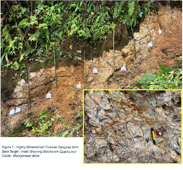
Figure 7 – Highly Mineralized Channel Samples from Bara Target – Inset Showing Stockwork Quartz-Iron Oxide – Manganese Veins
Island Passage will be issuing a year end update in early January with details on the planned 2026 exploration programs.
About Isina Resource Holdings Ltd. IRHL was founded in 2009 with the directors drawn from the chiefs of the ten major clans and their subclans in south Central Bougainville. As the custodians of their customary clan-owned land, the directors represent the customary landowner families. In an exercise of sovereignty over their mineral rights, they applied for and were granted EL02 over their lands. The licence comprises 250 km2 and is situated 9 km SE of the Panguna open pit along the Crown Prince Range, and extends a further 26 km to the SE.
About Island Passage Exploration Ltd. A private Canadian company purpose built in 2022 to facilitate the finance, technical, commercial, and business development expertise that will be necessary to drive exploration and development on Bougainville. The Company is founded on the principle of responsible resource development in partnership with indigenous and customary landowners, and its leadership has a long track record of success on multiple such ventures. IPX holds an option to earn a 70% interest in the tenement from IRHL.
About Island Passage Development Ltd. The PNG company is 100% owned by IPDC to bring exploration finance and technical capacity from Canada to Bougainville to carry out exploration on EL02.
For further information please go to islandpassage.ca
Or email Patrick Highsmith, President, at patrick@islandpassage.ca
Or follow IPX on Facebook at (3) Island Passage Development | Facebook
Or follow IPX on Linked-In (22) Island Passage Exploration Ltd.: Company Page Admin | LinkedIn
APPENDIX TO NEWS RELEASE – ADDITIONAL DATA AND FIGURE
Table A1 – Basic Statistics for Rock Samples from EL02 Project (Inception to September 2025)
The table can be accessed here: https://www.globenewswire.com/NewsRoom/AttachmentNg/005a2f72-c4e2-43f9-97af-eb60ed3f7493
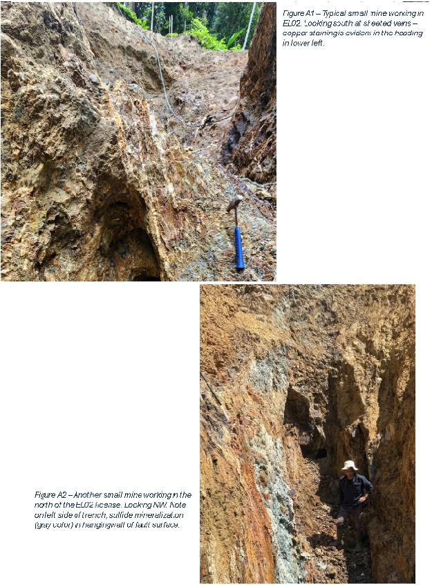
Figure A1 – Typical small mine working in EL02. Looking south at sheeted veins – copper staining is evident in the heading in lower left.
Figure A2 – Another small mine working in the north of the EL02 license. Looking NW. Note on left side of trench, sulfide mineralization (gray color) in hangingwall of fault surface.
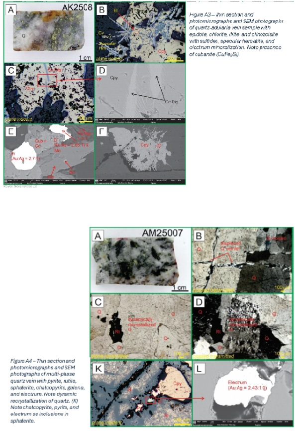
Figure A3 – Thin section and photomicrographs and SEM photographs of quartz-adularia vein sample with epidote, chlorite, illite, and clinozoisite with sulfides, specular hematite, and electrum mineralization. Note presence of cubanite (CuFe2S3).
Figure A4 – Thin section and photomicrographs and SEM photographs of multi-phase quartz vein with pyrite, rutile, sphalerite, chalcopyrite, galena, and electrum. Note dynamic recrystallization of quartz. (K) Note chalcopyrite, pyrite, and electrum as inclusions in sphalerite.
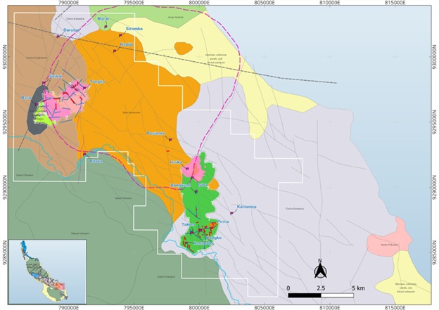
Figure A5 – Geologic Map of Bougainville Island Overlain with Preliminary Island Passage Mapping
Modified after “The Geology and Mineral Resources of Bougainville and Buka Islands, Papua New Guinea” by R. J. Rogerson, D.B. Hilyard, E.J. Finlayson, and R.W. Johnson, et al, 1989.
Table A2 – Detailed Results of Island Passage Bara Channel Sample AKCH56
The table can be accessed here: https://www.globenewswire.com/NewsRoom/AttachmentNg/da052b23-de8c-4383-8f5a-d339e99d7060
Photos accompanying this announcement are available at:
https://www.globenewswire.com/NewsRoom/AttachmentNg/07cd37d0-faf1-4e16-9e07-3587e10f9a1f
https://www.globenewswire.com/NewsRoom/AttachmentNg/1388ccd2-c3cc-4549-b29f-480f1c4f9fd2
https://www.globenewswire.com/NewsRoom/AttachmentNg/0a904582-276e-46ab-825b-019e8e14f64d
https://www.globenewswire.com/NewsRoom/AttachmentNg/59951cbd-b9d4-4c78-a890-dc073bd05833
https://www.globenewswire.com/NewsRoom/AttachmentNg/e6fab338-5bbe-486d-8d86-a1a2e16059c6
https://www.globenewswire.com/NewsRoom/AttachmentNg/2c0e0113-1a2b-469d-a343-6fe3ad9bfdf7
https://www.globenewswire.com/NewsRoom/AttachmentNg/b9807069-8044-408c-976a-108623d8470d
https://www.globenewswire.com/NewsRoom/AttachmentNg/158b7d55-2913-4fb2-a1ea-afe5d2fe2471
https://www.globenewswire.com/NewsRoom/AttachmentNg/53658885-763c-44c4-91ce-9f8928615ddb
https://www.globenewswire.com/NewsRoom/AttachmentNg/8c4cd5a6-89c5-458b-84df-245e12955a9a

![]()
Figure 1
Location Map of Bougainville Island and EL02 License
Figure 2

Copper in Rock Samples and Major Targets Across EL02
Figure 3
Gold in Rock Samples and Major Targets Across EL02
Figure 4
Preliminary Geologic Map of Isina Vein Target with Selected Channel Samples
Figure 5
Preliminary Geologic Map of Bara – Tangka Target with Selected Channel Samples
Figure 6
Copper (ppm) in Soil Sampling at the Bara – Tangka Target – Showing Selected Channel Samples
Figure 7

Highly Mineralized Channel Samples from Bara Target – Inset Showing Stockwork Quartz-Iron Oxide – Manganese Veins
Table A1
Basic Statistics for Rock Samples from EL02 Project (Inception to September 2025)
Figure A1 – Typical small mine working in EL02. Looking south at sheeted veins – copper staining is evident in the heading in lower left.
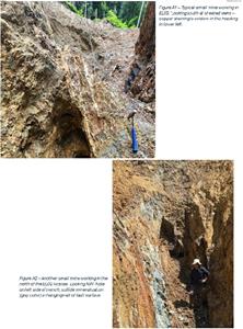
Figure A2 – Another small mine working in the north of the EL02 license. Looking NW. Note on left side of trench, sulfide mineralization (gray color) in hangingwall of fault surface.
Figure A3 – Thin section and photomicrographs and SEM photographs of quartz-adularia vein sample with epidote, chlorite, illite, and clinozoisite with sulfides, specular hematite, and electrum mineralization. Note presence of cubanite (CuFe2S3).
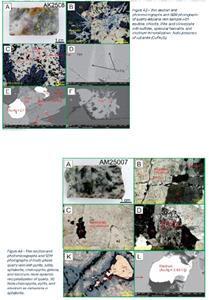
Figure A4 – Thin section and photomicrographs and SEM photographs of multi-phase quartz vein with pyrite, rutile, sphalerite, chalcopyrite, galena, and electrum. Note dynamic recrystallization of quartz. (K) Note chalcopyrite, pyrite, and electrum as inclusions in sphalerite.
Figure A5
Geologic Map of Bougainville Island Overlain with Preliminary Island Passage Mapping
Table A2