SAGA Metals Releases Corporate Video Produced by Pinnacle Digest and Provides a Comprehensive Summary of the Radar Ti-V-Fe Project in Labrador, Canada
07-Aug-2025 09:00:09 EDT
SAGA Metals Releases Corporate Video Produced by Pinnacle Digest and Provides a Comprehensive Summary of the Radar Ti-V-Fe Project in Labrador, Canada
GlobeNewswire August 07, 2025
VANCOUVER, British Columbia, Aug. 07, 2025 (GLOBE NEWSWIRE) — SAGA Metals Corp.(“SAGA” or the “Company”) (TSXV: SAGA) (OTCQB: SAGMF) (FSE: 20H), a North American exploration company focused on critical mineral discovery, is pleased to announce the release of its corporate video, produced by Pinnacle Digest, providing an overview of the Company as well as highlighting the key characteristics and developments of the Radar Titanium-Vanadium-Iron (Ti-V-Fe) Project in Labrador, Canada.
Located approximately 10 km from the town of Cartwright in southeastern Labrador, the Radar Project spans 24,175 hectares and fully encapsulates the Dykes River intrusive complex. Dykes River is a Mesoproterozoic layered mafic intrusion with strong geological similarities to globally significant AMCG (Anorthosite-Mangerite-Charnockite-Granite) suites. The geological setting of the project bears a resemblance to high-grade vanadiferous titanomagnetite (VTM) systems such as China's Panzhihua VTM deposit and the Tellnes deposit in Norway1. With a large oxide layering thickness, a near-monomineralic VTM composition, and extensive mineral tenures, the Radar Project shows the potential to become a globally significant VTM project.
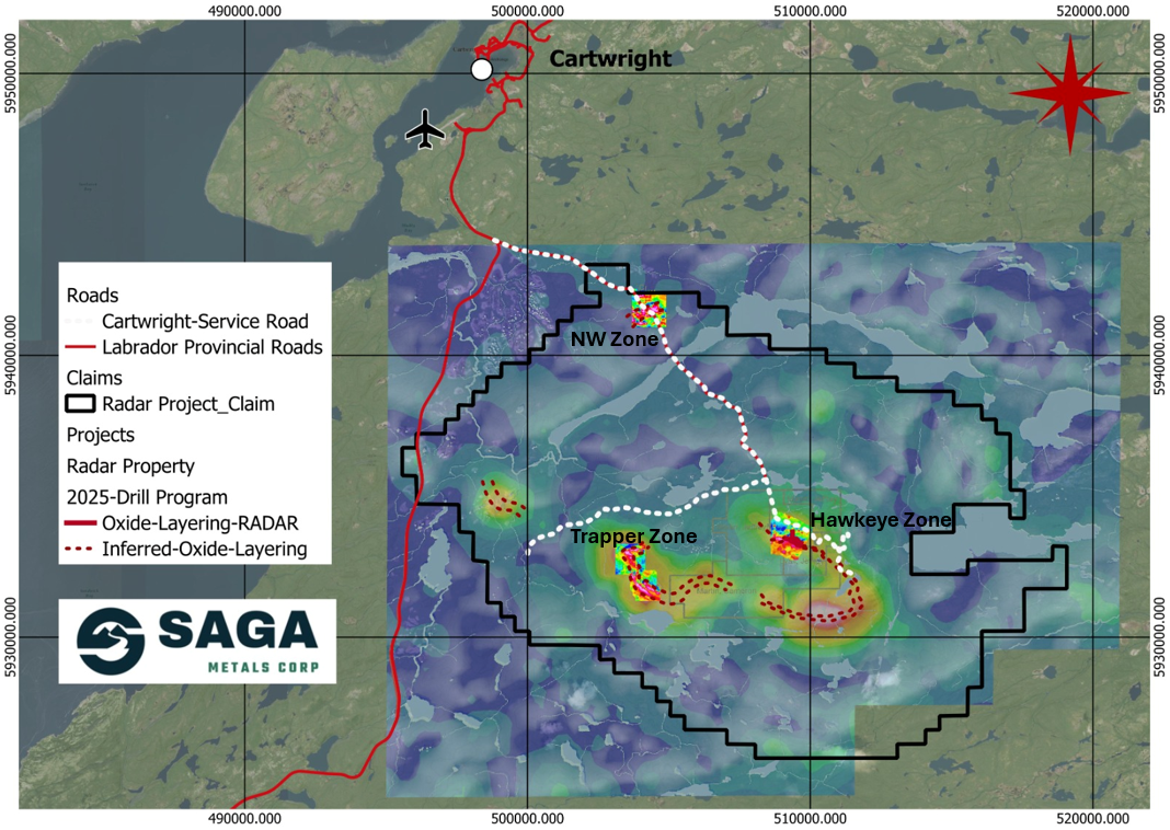
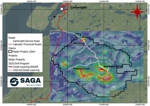
Figure 1: Radar Property map, depicting magnetic anomalies, oxide layering and the site of the 2025 drill program in the Hawkeye zone. The Property is well serviced by road access and is conveniently located near the town of Cartwright, Labrador. A compilation of historical aeromagnetic anomalies is overlaid by ground-based geophysics as shown. SAGA has demonstrated the reliability of the regional airborne magnetic surveys after ground-truthing and drilling in the 2024 and 2025 field programs.
The Company has completed a successful year of exploration activities, including geophysical surveys, a maiden drill campaign, geological mapping, petrographic analysis, and strategic infrastructure upgrades, which have significantly advanced the understanding of the property's potential. The culmination of these activities has revealed that the oxide-rich layering is expressed as a magnetic high anomaly across a strike length of more than 20 km, forming the core of exploration within the Hawkeye and Trapper zones.
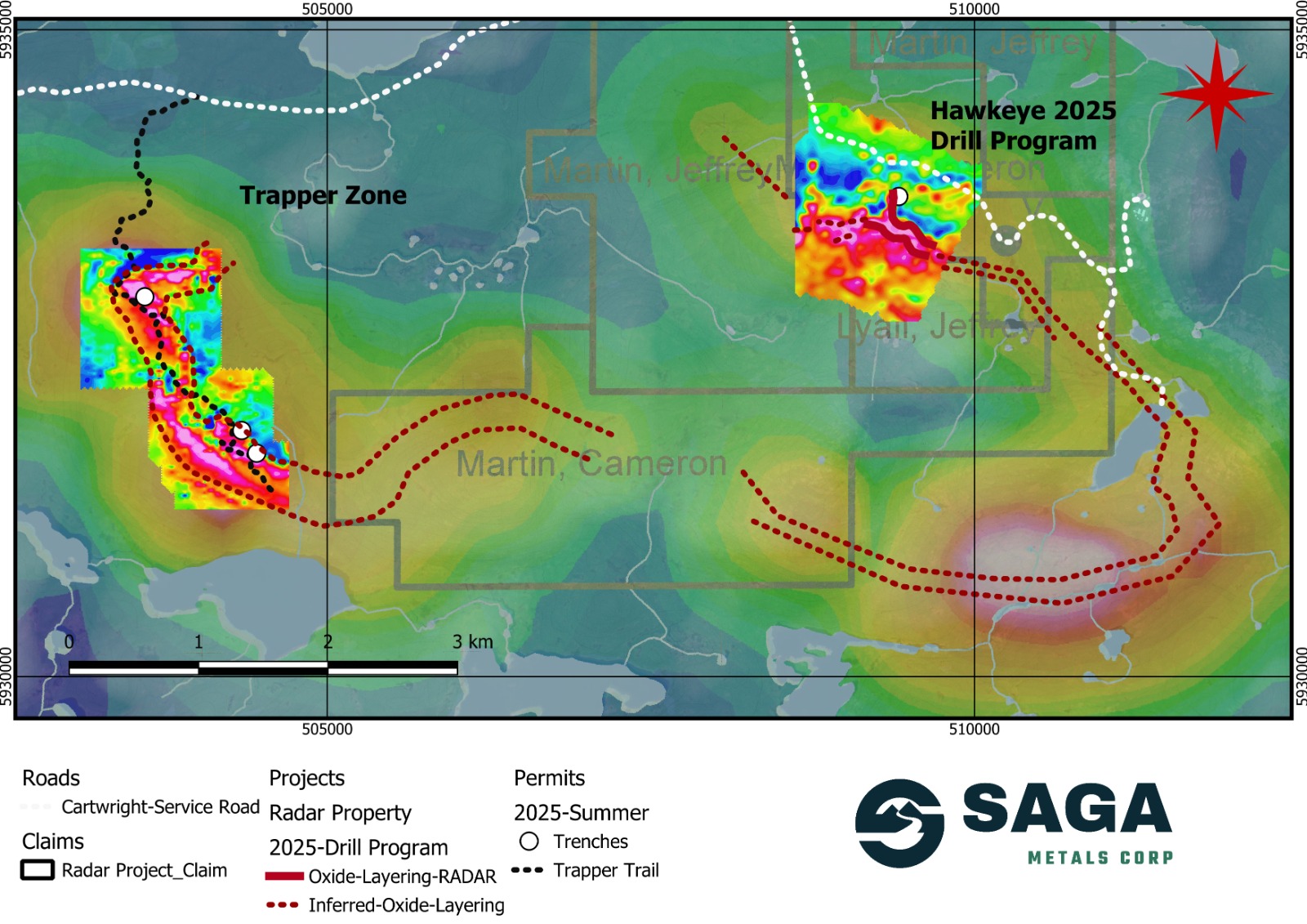
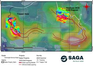
Figure 2: Radar Project's prospective oxide layering zone extends for an inferred 20 km strike length, as shown on a compilation of historical airborne geophysics as well as ground-based geophysics in the Hawkeye and Trapper zones completed by SAGA in the 2024/2025 field programs. SAGA has demonstrated the reliability of the regional airborne magnetic surveys after ground-truthing and drilling in the 2024 and 2025 field programs.
SAGA's 2025 Winter Drill Program at Radar:
Saga's 2025 winter maiden drilling program featured a 2,209-metre, seven-hole diamond drill campaign across the Hawkeye Zone–a combination of 3D magnetic inversion modeling and surface VLF-EM results guided drill targeting. The program intersected broad zones of titanomagnetite-rich oxide layering, with cumulative intersections displaying consistent grades of titanium dioxide (TiO2), vanadium pentoxide (V2O5) and iron (Fe).
Similarities in the ratios of TiO2 and V2O5 to Fe3O4 across multiple drill holes serve to identify discrete igneous layers. Within the 600 m tested thickness of the layered gabbronorite, the chemistry delineates a very promising 300-400 m thickness, referred to as the Lower Cumulate Layer. The highest V2O5 assays are in the lower 100-200 m, coinciding with the highest-grade intervals of VTMs. The layer is comprised of interlayered gabbronorite and bands of semi-massive to massive VTM.
Drill holes R25-HEZ-01, -07, -04, and -05 intersect this Lower Cumulate Layer. The chemistry indicates that the layer was deposited from a single, large-volume pulse of Ti-V-Fe-enriched magma.
Hawkeye Zone – Significant Drill Intersections
Drill Hole
Interval Length (m)
Average VTM (%)
Maximum VTM (%)
R25-HEZ-01
263.5
25.9%
35.2%
R25-HEZ-07
311.7
23.0%
41.6%
R25-HEZ-04
208.5
29.6%
35.2%
R25-HEZ-05
187.3
26.8%
26.8%
Maximum VTM is based on about a minimum 10 m interval All intervals are within the Lower Cumulate Layer
Table 1: Lower Cumulate Layer highlighting the length of VTM intersections.
The significant length-weighted averages at Hawkeye are in the range of 20 to 35% VTM. In other mafic layered intrusions, that tenor of mineralization lies within an economic range.
SUMMARY OF DRILLING RESULTS – 2024-25 WINTER PROGRAM – LENGTH WEIGHTED AVERAGES
Hole_ID
From
To
Length_m
Fe (%)
Fe3O4 (%)
TiO2 (%)
V2O5 (%)
Estimated VTM (%)
VTM Habit
R25-HEZ-01
4.5
268.0
263.5
17.53
24.20
3.66
0.17
25.90
Evenly distributed mineralization
R25-HEZ-01
151.1
198.5
47.4
23.27
32.13
4.83
0.25
35.08
Included Semi-Massive to Massive
R25-HEZ-01
206.0
218.7
12.7
23.38
32.29
4.74
0.26
35.16
Included Semi-Massive to Massive
R25-HEZ-01
236.5
246.0
9.5
23.35
32.24
4.65
0.28
35.04
Included Semi-Massive to Massive
R25-HEZ-02
1.5
62.2
60.7
14.29
19.73
3.24
0.10
20.94
Intercumulus
R25-HEZ-02
39.5
62.2
22.7
15.13
20.90
3.43
0.10
22.30
Intercumulus
R25-HEZ-02
122.5
300.0
177.5
12.49
17.25
3.86
0.07
19.04
Intercumulus
R25-HEZ-03
4.0
149.0
145.0
14.69
20.28
3.13
0.10
21.38
Intercumulus
R25-HEZ-04
4.5
98.8
94.3
13.85
19.12
2.96
0.10
20.05
Intercumulus
R25-HEZ-04
99.6
308.0
208.5
19.92
27.51
3.99
0.22
29.59
Intercumulus
R25-HEZ-04
222.0
272.2
50.2
23.40
32.32
4.54
0.29
35.02
Included Semi-Massive to Massive
R25-HEZ-05
4.5
117.2
112.7
14.21
19.62
3.31
0.09
20.89
Intercumulus
R25-HEZ-05
117.2
304.5
187.3
18.06
24.94
3.77
0.18
26.76
Intercumulus
R25-HEZ-06
75.5
293.0
217.5
14.34
19.80
3.07
0.12
20.85
Intercumulus
R25-HEZ-06
265.0
293.0
28.0
20.11
27.77
4.22
0.21
30.08
Included Higher Grade
R25-HEZ-07
2.3
314.0
311.7
15.94
22.02
2.88
0.18
22.95
Intercumulus
R25-HEZ-07
86.8
205.2
118.4
23.22
32.07
4.51
0.30
34.75
Included Semi-Massive to Massive
R25-HEZ-07
225.7
236.0
10.3
27.55
38.05
5.34
0.38
41.63
Included Semi-Massive to Massive
Intervals with >35% VTM = Semi-Massive to Massive VTM
Intervals with >20% VTM = Intercumulus VTM, with some layers of semi-massive to massive VTM.
Length is the core interval. True thickness are about 80% of the core interval.
Table 2: Summary of Saga Metals Radar Project 2025 drill results on the Hawkeye zone withVTM calculation & classification
Geological and petrographic assessments reveal that the layered sequences have preserved their primary magmatic textures, supporting a robust interpretation of their geochemical consistency. These findings have significant implications for potential metallurgical simplicity and recovery efficiency.
SAGA's 2025 Summer Exploration Program at Radar:
Following the winter drill program, SAGA initiated an aggressive geophysical expansion effort focused on the Trapper and Northwest Zones, confirming the presence of oxide layering. SAGA's geophysics team confirmed a 3 km continuous magnetic anomaly in the Trapper zone, containing the highest readings to date, and remains open in both directions along strike.
In a similar fashion to the Hawkeye zone, SAGA's geophysics team reports strong magnetic responses within the Trapper zone, requiring recalibration of the geophysical instruments. While readings exceeded 74,000 nT in the Hawkeye zone, at the Trapper zone, they observed responses as high as 115,498 nT over the northern Trapper zone and over 113,000 nT over the southern Trapper zone. In some cases, the instruments reached the maximum level of detection (120,000 nt).
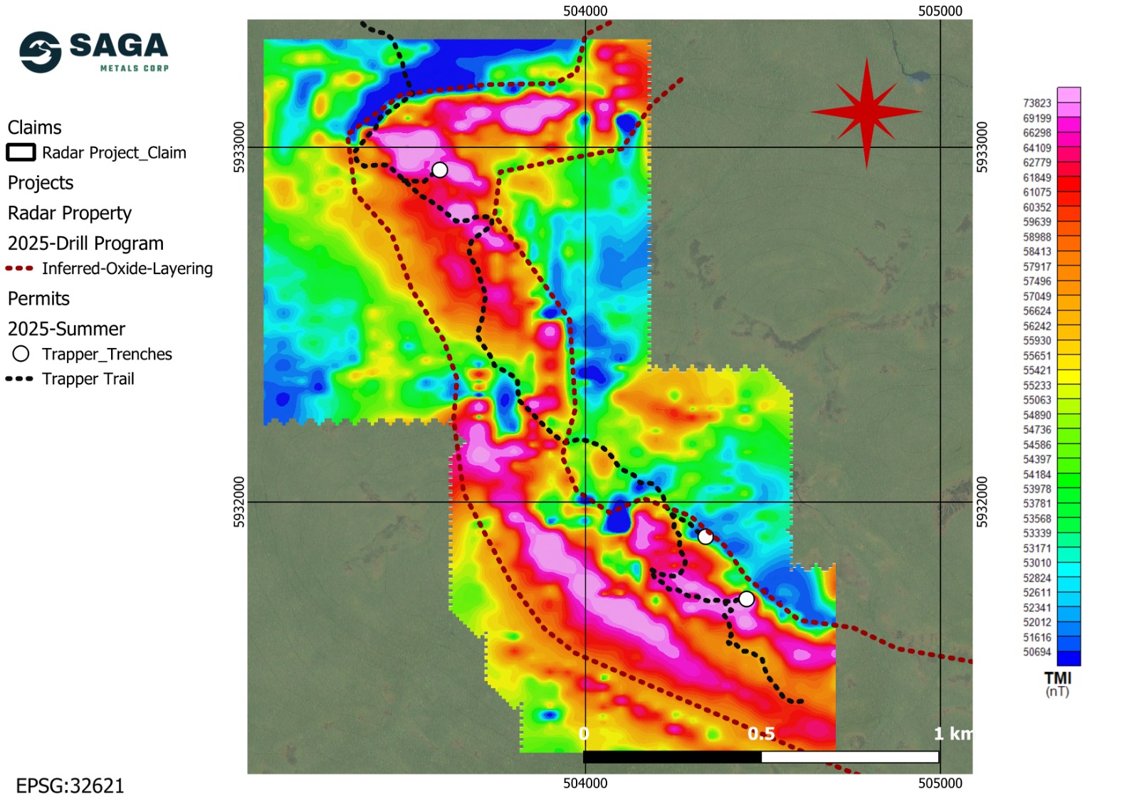
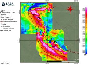
Figure 3: Radar Project's Trapper Zone depicting a 3 km magnetic anomaly and oxide layering trend. The Trapper Trail (in black) will support a new diamond drilling program.
To support expanded exploration, Saga undertook a strategic infrastructure initiative, including the clearance of a legacy forestry road and the construction of a 4 km access trail across the Trapper Zone. This access route has enabled efficient trenching, mobilization of heavy equipment, and the advancement of follow-up drilling programs across the oxide corridor. The Company completed approximately 504 square metres (5,425ft2) of trenching in magnetite-rich horizons within Trapper, uncovering semi-massive and massive mineralization at surface.
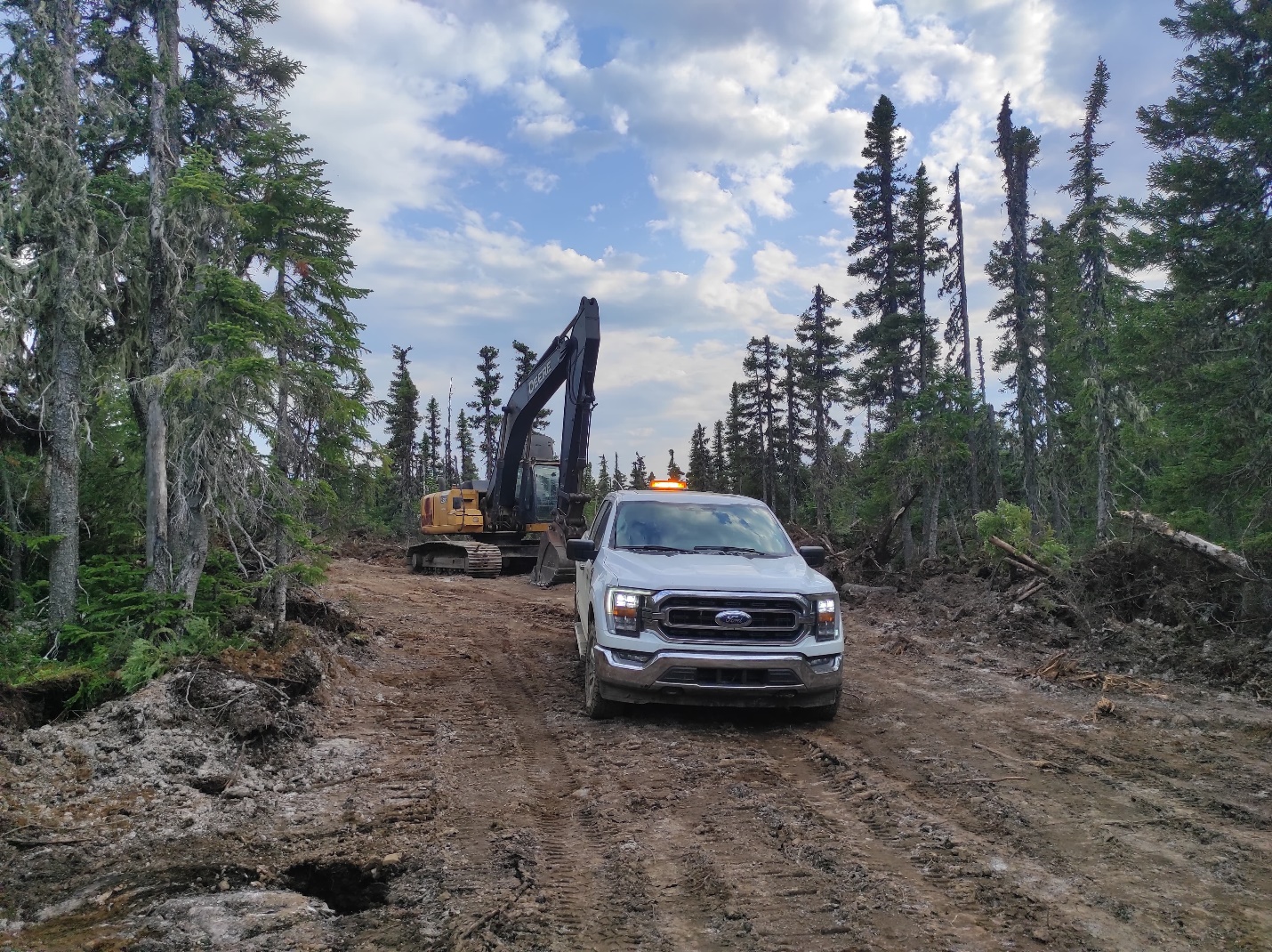
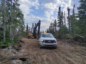
Figure 4: Excavator and work truck located along the Trapper Trail over the northern portion of the oxide layer trend within the Trapper zone.
Community support remains a cornerstone of the Company's operations in Labrador. In April 2025, the Town of Cartwright issued an official letter of support for SAGA and its ongoing exploration efforts at Radar. The Company has maintained a collaborative relationship with local stakeholders and engaged community members directly in field operations, exemplified by the involvement of Cartwright-based personnel in geophysical surveys and logistical operations. The town's proximity to the project provides reliable all-season road access, deep-water port facilities, a regional airport, and close access to hydroelectric power infrastructure.
To strengthen technical governance and ensure compliance with National Instrument 43-101 standards, Saga appointed Paul J. McGuigan, P.Geo., as the Company's Independent Qualified Person in June 2025. Mr. McGuigan brings over five decades of experience in layered mafic intrusions, deposit modeling, QA/QC, and resource classification methodologies. His oversight has reinforced the integrity of the exploration approach and supports the Company's technical reporting as it advances toward resource delineation.
In mid-July, SAGA disclosed results from a detailed petrographic and mineralogical study confirming the dominance of titanomagnetite in the Hawkeye zone. From our assay results, we know the titanomagnetite mineralization is accompanied by vanadium. Ilmenite is almost entirely present as inclusions in magnetite. Similar to the Panzhihua deposit in China, VTM is expected to be recovered as a V-Ti-Fe concentrate. Panzhihua is the world's largest single-site producer of Fe-Ti-V magnetite ore, resulting in a significant production volume of 40-50% of global vanadium supply, making it #1 globally. The vertical integration of its production is primarily focused on the igneous layers of VTM2.
Looking ahead, Saga Metals is preparing for an expanded drilling program at the Trapper Zone, informed by inversion modeling and surface trenching results. The 2025 field campaigns will prioritize resource expansion, metallurgy sampling, and structural mapping to support a future mineral resource estimate.
Saga Metals Corp. remains committed to responsible exploration, strong community engagement, and the strategic development of critical metals that support decarbonization and energy security.
Paul J. McGuigan, P. Geo., is an Independent Qualified Person as defined under National Instrument 43-101 and has reviewed and approved the technical information related to the Radar Ti-V-Fe Project disclosed in this news release.
About SAGA Metals Corp.
SAGA Metals Corp. is a North American mining company focused on the exploration and discovery of a diversified suite of critical minerals that support the global transition to green energy. The Radar Titanium Project comprises 24,175 hectares and entirely encloses the Dykes River intrusive complex, mapped at 160 km(2) on the surface near Cartwright, Labrador. Exploration to date, including a 2,200m drill program, has confirmed a large and mineralized layered mafic intrusion hosting vanadiferous titanomagnetite (VTM) with strong grades of titanium and vanadium.
The Double Mer Uranium Project, also in Labrador, covers 25,600 hectares featuring uranium radiometrics that highlight an 18km east-west trend, with a confirmed 14km section producing samples as high as 0.428% U3O8 and uranium uranophane was identified in several areas of highest radiometric response (2024 Double Mer Technical Report).
Additionally, SAGA owns the Legacy Lithium Property in Quebec's Eeyou Istchee James Bay region. This project, developed in partnership with Rio Tinto, has been expanded through the acquisition of the Amirault Lithium Project. Together, these properties cover 65,849 hectares and share significant geological continuity with other major players in the area, including Rio Tinto, Winsome Resources, Azimut Exploration, and Loyal Metals.
With a portfolio that spans key minerals crucial to the green energy transition, SAGA is strategically positioned to play an essential role in the clean energy future.
Neither the TSX Venture Exchange nor its Regulation Service Provider (as that term is defined in the policies of the TSX Venture Exchange) accepts responsibility for the adequacy or accuracy of this release.
Cautionary Disclaimer
This news release contains forward-looking statements within the meaning of applicable securities laws that are not historical facts. Forward-looking statements are often identified by terms such as “will”, “may”, “should”, “anticipates”, “expects”, “believes”, and similar expressions or the negative of these words or other comparable terminology. All statements other than statements of historical fact, included in this release are forward-looking statements that involve risks and uncertainties. In particular, this news release contains forward-looking information pertaining to the exploration of the Company's Radar Project. There can be no assurance that such statements will prove to be accurate and actual results and future events could differ materially from those anticipated in such statements. Important factors that could cause actual results to differ materially from the Company's expectations include, but are not limited to, changes in the state of equity and debt markets, fluctuations in commodity prices, delays in obtaining required regulatory or governmental approvals, environmental risks, limitations on insurance coverage, inherent risks and uncertainties involved in the mineral exploration and development industry, particularly given the early-stage nature of the Company's assets, and the risks detailed in the Company's continuous disclosure filings with securities regulations from time to time, available under its SEDAR+ profile at www.sedarplus.ca. The reader is cautioned that assumptions used in the preparation of any forward-looking information may prove to be incorrect. Events or circumstances may cause actual results to differ materially from those predicted, as a result of numerous known and unknown risks, uncertainties, and other factors, many of which are beyond the control of the Company. The reader is cautioned not to place undue reliance on any forward-looking information. Such information, although considered reasonable by management at the time of preparation, may prove to be incorrect and actual results may differ materially from those anticipated. Forward-looking statements contained in this news release are expressly qualified by this cautionary statement. The forward-looking statements contained in this news release are made as of the date of this news release and the Company will update or revise publicly any of the included forward-looking statements only as expressly required by applicable law.
Photos accompanying this announcement are available at:
Radar Property map, depicting magnetic anomalies, oxide layering and the site of the 2025 drill program in the Hawkeye zone. The Property is well serviced by road access and is conveniently located near the town of Cartwright, Labrador. A compilation of historical aeromagnetic anomalies is overlaid by ground-based geophysics as shown. SAGA has demonstrated the reliability of the regional airborne magnetic surveys after ground-truthing and drilling in the 2024 and 2025 field programs.
Figure 2
Radar Project's prospective oxide layering zone extends for an inferred 20 km strike length, as shown on a compilation of historical airborne geophysics as well as ground-based geophysics in the Hawkeye and Trapper zones completed by SAGA in the 2024/2025 field programs. SAGA has demonstrated the reliability of the regional airborne magnetic surveys after ground-truthing and drilling in the 2024 and 2025 field programs.
Figure 3
Radar Project's Trapper Zone depicting a 3 km magnetic anomaly and oxide layering trend. The Trapper Trail (in black) will support a new diamond drilling program.
Figure 4
Excavator and work truck located along the Trapper Trail over the northern portion of the oxide layer trend within the Trapper zone.